The ChiliView Series - Kings Canyon National Park East The ChiliView Series - Kings Canyon National Park East
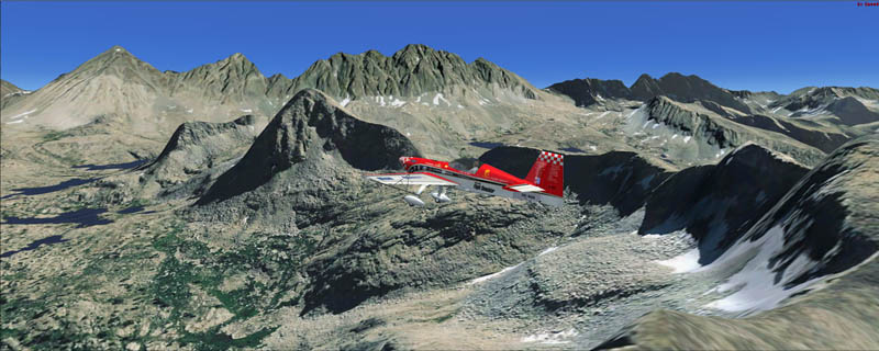
Kings Canyon is another fine example of a huge canyon formed by glaciers during the last ice age. It is one of the deepest canyons in the US. East of the canyons you can soar above the high peaks of the Sierra Crest culminating in 14.248ft high North Palisade. Mountain flying Tip: Don't get up too high. You will get the best and most spectacular views by flying below the mountain tops. There's no better impression of flying than crossing a ridge and soaring over the abyss on the other side. However for safety reasons, experienced pilots recommend crossing a ridge or pass at ridge elevation plus at least 1.000ft (2.000ft if the wind at ridge elevation is above 20kts). Plan to be at that altitude at least three miles before the crossing and maintain that altitude for at least three miles past it to avoid the most severe turbulence and down drafts in windy conditions. Furthermore FAA requests to maintain a minimum of 2.000ft AGL above National Parks. Ridges should be crossed at a 45° angle so that you can turn away quicker if you encounter any problems. After crossing a ridge, fly away from it directly to get away from the most likely area of turbulence and down drafts.
It covers a total of 3625 sq km.
For FSX and Prepar3D.
The resolution of 1 m/pix brings you razor-sharp images even near the ground.
Best enjoyed in low and slow operations!
Also contains a 10 m high resolution elevation mesh.
Navigate to neighboring regions:
North
South
East
West
|
!!! BlueSkyScenery needs YOUR help !!!
If you like our sceneries, then please give a little donation.
Your donation makes a difference and helps us to continue this project!
|
Give $1.00:
|
|
|
Give $5.00:
|
|
|
Give $10.00:
|
|
|
Give $20.00:
|
|
Download:
|
FS9 Version:
|
Scenery
|
Airports
|
| |
|
For FSX & P3D:
|
Scenery
|
Airports
|
Scenery Mirror
|
You can support the freeware project by visiting our sponsored links:
|
|
|
All information on this site strictly for simulation use only!
All Trademarks copyrighted. (c) by BlueSkyScenery. All rights reserved.

|
|
|