The ChiliView Series - North Las Vegas (KVGT), Nellis AFB (KLSV) The ChiliView Series - North Las Vegas (KVGT), Nellis AFB (KLSV)
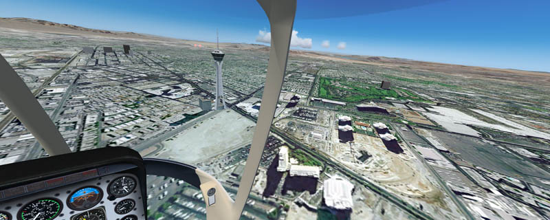
This region covers the northern part of Las Vegas, including Nellis AFB (KLSV) and North Las Vegas(KLSV). It goes north to the southern boundary of Nellis Air Force Range including the Indian Springs AF Aux Field and west to Mount Charleston.
It covers a total of 3625 sq km.
For FSX and Prepar3D.
The resolution of 1 m/pix brings you razor-sharp images even near the ground.
Best enjoyed in low and slow operations!
Also contains a 10 m high resolution elevation mesh.
Navigate to neighboring regions:
South
East
West
|
!!! BlueSkyScenery needs YOUR help !!!
If you like our sceneries, then please give a little donation.
Your donation makes a difference and helps us to continue this project!
|
Give $1.00:
|
|
|
Give $5.00:
|
|
|
Give $10.00:
|
|
|
Give $20.00:
|
|
Download:
|
FS9 Version:
|
Scenery
|
Airports
|
| |
|
For FSX & P3D:
|
Scenery
|
Airports
|
Scenery Mirror
|
You can support the freeware project by visiting our sponsored links:
|
|
|
All information on this site strictly for simulation use only!
All Trademarks copyrighted. (c) by BlueSkyScenery. All rights reserved.

|
|
|