The ChiliView Series - Canyonlands National Park, The Maze/North & Green River Canyon v2.0 The ChiliView Series - Canyonlands National Park, The Maze/North & Green River Canyon v2.0
More screenies:
Prev
Next
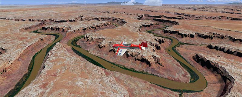
The Maze is the wildest and least accessible district of Canyonlands National Park. It is a perplexing jumble of canyons that has been described as a '30 sq miles puzzle in sandstone'. The Maze covers the area west of the Green River and north of the Colorado River. Getting to most locations requires multiple hours of 4WD road driving. Hiking trails usually require multi day backpack trips. Too strenous? Let's go flying! Checking out the area from an eagles perspective is certainly a stunning experience. The colors are awesome and the landforms are of breathtaking beauty. The scenery extends my Arches National Park scenery to the west and covers the area from south of the city of Green River to just north of the confluence of the Colorado and Green Rivers. This is a remake of an earlier release with better and newer imagery.
It covers a total of 3625 sq km.
For FSX and Prepar3D.
The resolution of 1 m/pix brings you razor-sharp images even near the ground.
Best enjoyed in low and slow operations!
Also contains a 10 m high resolution elevation mesh.
Navigate to neighboring regions:
North
South
East
West
|
!!! BlueSkyScenery needs YOUR help !!!
If you like our sceneries, then please give a little donation.
Your donation makes a difference and helps us to continue this project!
|
Give $1.00:
|
|
|
Give $5.00:
|
|
|
Give $10.00:
|
|
|
Give $20.00:
|
|
Download:
|
FS9 Version:
|
Scenery
|
Airports
|
| |
|
For FSX & P3D:
|
Scenery
|
Airports
|
Scenery Mirror
|
You can support the freeware project by visiting our sponsored links:
|
|
|
All information on this site strictly for simulation use only!
All Trademarks copyrighted. (c) by BlueSkyScenery. All rights reserved.

|
|
|