The ChiliView Series - Cedar Breaks National Monument, Cedar City (KCDC) v2.0 The ChiliView Series - Cedar Breaks National Monument, Cedar City (KCDC) v2.0
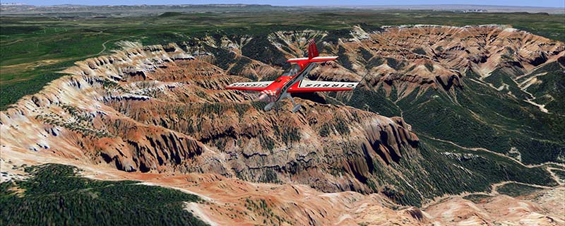
Cedar Breaks National Monument is a large amphitheater cliff in bright colors of red, orange and purple. It lies east of Cedar City in the northern region of the scenery. The cliff was formed by erosion thru wind, water and ice. Today erosion continues with a pace of about 2 inches every 5 years. Although it is called Cedar Breaks, there are no cedars growing there but juniper trees. For a scenic flight to Cedar Breaks National Monument best depart from Cedar City Regional Airport (KCDC) and head east. This is a remake of an earlier release with better and newer imagery.
It covers a total of 3625 sq km.
For FSX and Prepar3D.
The resolution of 1 m/pix brings you razor-sharp images even near the ground.
Best enjoyed in low and slow operations!
Also contains a 10 m high resolution elevation mesh.
Navigate to neighboring regions:
North
South
East
West
|
!!! BlueSkyScenery needs YOUR help !!!
If you like our sceneries, then please give a little donation.
Your donation makes a difference and helps us to continue this project!
|
Give $1.00:
|
|
|
Give $5.00:
|
|
|
Give $10.00:
|
|
|
Give $20.00:
|
|
Download:
|
FS9 Version:
|
Scenery
|
Airports
|
| |
|
For FSX & P3D:
|
Scenery
|
Airports
|
Scenery Mirror
|
You can support the freeware project by visiting our sponsored links:
|
|
|
All information on this site strictly for simulation use only!
All Trademarks copyrighted. (c) by BlueSkyScenery. All rights reserved.

|
|
|